
Fyfeshire Dam Conservation Area
Assessor’s Map and Parcel(s): 3.A-83, 3.A-44, 3.A-43
Acres: 38.08
Acquired: Four parcels were gifted to the town.
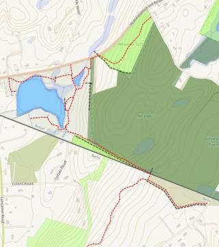
Features: meandering trail with extensions leading into Haynes Wheeler property, peach hill road and through the Wendler property in Berlin (Mountain Laurel Trail). The trail crosses a foot bridge above the sluiceway adjacent to the upper pond. A second bridge parallels Wattaquadock Hill road. Then provides excellent wildlife viewing through a grass covered overlook by the spillway of Wattaquadock Pond.
Natural features: consisting of forested and non-forested wetland surrounded by mixed deciduous/coniferous upland forested areas. The land is situated between Wattaquadock Hill Road, residential single-family homes and land under an Agricultural Preservation Restriction encompassing Nicewicz family farm. The two ponds on the property are fed by the perennial stream North Brook that descends beneath Wattaquadock Hill Road South West toward the Berlin town line.
The Upper Pond known as “Mosquito Pond” but is otherwise unnamed, is categorized as a Freshwater Pond in the National Wetlands Inventory. The riverine “North Brook” flows from this freshwater pond into freshwater/Shrub wetland before reaching adjacent freshwater emergent wetland that through the riverine pathway flows across town boundaries into Berlin Wildlife Management Area. The National Wetland Inventory establishes the larger portion of the lower ponded area to be Freshwater emergent wetland adjacent to the freshwater forested/shrub wetland fed by the riverine that flows from the upper freshwater pond.
Access: Parking area off of Wattquadock Hill Road at stone entryway. The trails connect as established above therefore additional parking may be found at these locations (Lancaster Road, Sawyer Road, Peach Hill Road).
History: originally owned by William Fyfe (hence the name) the property was home to agriculture and later, other forms of commerce. When these businesses were no longer successful Mrs. Helen Plummer eventually inherited the property. She built a small cabin there. After many years, in honor of her family and to prevent further subdivision of the property; she donated the property to the Town of Bolton for conservation land in 1969. This donation also inspired the donation of woodland for the same purpose from the Wheeler family. An additional parcel was donated to the town in 2020 that connects the open space in Bolton through Berlin and into Clinton creating a multi-parcel wildlife corridor with only one road crossing (Lancaster Road)
Trails: HERE
Regulations for Use of Conservation Land
It is the intent and policy of the Conservation Commission that conservation land be maintained in a natural state. Some areas where appropriate the commission establishes trails to allow for passive recreational use. Any alteration to a Conservation property or trail by persons other than the Commission's authorized agents shall require the prior written permission of the Commission. The Conservation Land Rules and Regulations shall be adhered to at all times. Inclusive of the Dogs on Conservation Land Rules and Regulations. You may find these regulations on our town website or by clicking HERE.
This property will be conserved in its natural state for the purposes of:
“my grandfather wished it given to charity to be kept in its natural state for the beautiful spot for ever. Also to be called Fyfeshire…”
(original letter of interest from Helen L. Plummer for donation of land written August 1969)
- Town shall be trustee under this trust
- The Conservation Commission shall manage and control the property conveyed to this public charitable trust
- The property shall be used for the purposes authorized by G.L. Chapter 40 Section 8C as it may here after be amended and the protection and development of the natural resource and the protection of the watershed resources of the town of Bolton.
- The property shall be named and hereafter designated as Fyfeshire
Adopted 12/21/2010
The maps and data displayed on this site are for reference and planning purposes only. The Town of Bolton assumes no legal responsibility for the information contained herein. The items specified above are restrictions specific to the conservation property. They are included for transparency purposes only. They do not give anyone the right to alter conservation property. That is ONLY the authority of the conservation commission or its authorized agents.