
Butternut
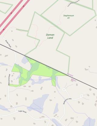
Assessor’s Map and Parcel(s): 6.E-43, 6.E-56, 6.E-38, 6.E-1.1
Acres: ~29.78
Acquired: The Butternut parcels were acquired as part of the FOSPRD process in 2000, the Whitcomb parcel was acquired through a land donation resulting from the Massachusetts Conservation Land Tax Credit Program Donation.
Features: Meadow and field areas
Access: Hubbard Lane, Sugar Road or Whitcomb road.
Trails: HERE
Regulations for Use of Conservation Land
It is the intent and policy of the Conservation Commission that conservation land be maintained in a natural state. Some areas where appropriate the commission establishes trails to allow for passive recreational use. Any alteration to a Conservation property or trail by persons other than the Commission's authorized agents shall require the prior written permission of the Commission. The Conservation Land Rules and Regulations shall be adhered to at all times. Inclusive of the Dogs on Conservation Land Rules and Regulations. You may find these regulations on our town website or by clicking HERE.
In addition to the regulations referenced above, the following restrictions apply:
- Parcels shall remain in their natural, scenic and open condition and shall be used only for passive recreation such are nature/walking trails and agriculture and forestry uses;
- No motorized vehicles of any type or kind shall be allowed, except as necessary for agricultural or selective clearing operations and to the extent access is required for fire, police or other emergency vehicles;
- No above-ground structures of any type or kind shall be constructed on the parcels except for walkways, pedestrian footbridges and fencing appropriate to the conservation purposes of the parcels;
- Except for the maintenance of nature/walking trails, no trees shall be cut or vegetation removed unless the same are dead or diseased or cause a safety hazard;
- The parcels shall not be conveyed to the Commonwealth of Massachusetts or any other entirety including but not limited to any non-profit conservation trust, unless same is controlled in its entirety by the town of Bolton, it being the intent of this grant that the parcels be used and enjoyed by the Inhabitants of the Town of Bolton;
- No activities that are or may be detrimental to drainage, flood control, water conservation, erosion control or soil conservation shall be performed on the parcels;
- No hunting or trapping of animals or discharging of firearms shall be allowed on the parcels;
- No fires for recreational or cooking purposes shall be allowed on the parcels;
- No other use or activity which would be detrimental to the preservation of the parcels in an open and natural condition or which would otherwise be inconsistent with the purposes of this deed shall be allowed on the parcels
Notwithstanding the foregoing, the following activities are expressly permitted on the parcels:
- The maintenance of presently existing trails and wood roads; and
- The cultivation and harvesting of open field crops, flowers, shrubs, trees and hay, and the mowing of grass.
Adopted 12/21/2010
The maps and data displayed on this site are for reference and planning purposes only. The Town of Bolton assumes no legal responsibility for the information contained herein. The items specified above are restrictions specific to the conservation property. They are included for transparency purposes only. They do not give anyone the right to alter conservation property. That is ONLY the authority of the conservation commission or its authorized agents.